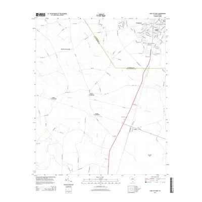
2014 Map of Lake City West
USGS Topo · Published 2014About this map
The boundary between Florence Co and Williamsburg Co runs diagonally through this 2014 survey, dividing the commercial and residential reach of Lake City from the rural crossroads of the south. The city's western expansion is anchored by the Lake City Municipal Airport-CJ Evans Field, while the downtown core reveals a grid of historic streets and the Lake City Presbyterian Cem. This landscape transition is marked by a network of rural hubs including Hogeye Crossroads, Moore Crossroads, and Clarks Crossroads, which served as vital local junctions long before modern highway development.
Find a feature on this map
105 named features on this map. Tap any name to fly to it.
Don’t see what you’re looking for? This feature index may not catch every label — zoom into the map to look around manually.
Map Details
Editions of this 2014 Lake City West Map
This is the sole edition of this map. No revisions or reprints were ever made.
Other maps of this area

1946 · Hyman
USGS Topo · 1:62,500

1946 · Kingstree
USGS Topo · 1:62,500

1946 · Lake City
USGS Topo · 1:62,500

1946 · Indiantown
USGS Topo · 1:62,500

1949 · Georgetown
USGS Topo · 1:250,000

1967 · Georgetown
USGS Topo · 1:250,000

1974 · Georgetown
USGS Topo · 1:250,000

1986 · Kingstree
USGS Topo · 1:100,000
1990 · Hebron Crossroads
USGS Topo · 1:24,000
1990 · Olanta
USGS Topo · 1:24,000