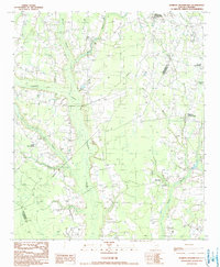
1990 Map of Hebron Crossroads
USGS Topo · Published 1990About this map
Pudding Swamp dominates the central corridor of this coastal plain landscape, defining the boundaries and movement between Clarendon and Williamsburg Counties. The map reveals a rural settlement pattern anchored by historically significant hubs like Hebron Crossroads and Barrineau Crossroads, where local commerce and community life converged. Farther south, the transition from swampy lowlands to cultivated ground is marked by Spring Bank Plantation and Holly Tree Plantation, indicating the long-standing agricultural focus of the region. Numerous tributary streams, including Rose Creek, Douglas Swamp, and Long Branch, feed into the larger basins, creating a complex drainage system that dictated where early roads and homesteads were established. For genealogists, the placement of several small Cem sites provides essential coordinates for tracing families across this quiet section of the South Carolina lowcountry.
Find a feature on this map
19 named features on this map. Tap any name to fly to it.
Don’t see what you’re looking for? This feature index may not catch every label — zoom into the map to look around manually.
Map Details
Editions of this 1990 Hebron Crossroads Map
This is the sole edition of this map. No revisions or reprints were ever made.
Other maps of this area

1920 · Mayesville
USGS Topo · 1:48,000

1920 · Manning
USGS Topo · 1:48,000

1921 · Manning
USGS Topo · 1:62,500

1921 · Mayesville
USGS Topo · 1:62,500

1943 · Mayesville
USGS Topo · 1:62,500

1944 · Manning
USGS Topo · 1:62,500

1946 · Kingstree
USGS Topo · 1:62,500

1946 · Lake City
USGS Topo · 1:62,500

1949 · Georgetown
USGS Topo · 1:250,000

1954 · Augusta
USGS Topo · 1:250,000
Featured Places
- Hebron Crossroads, SC
- Union Crossroads, SC
- Barrineau Crossroads, SC
- Terrell Crossroad, SC
- Clarendon County, SC