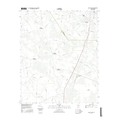
2017 Map of Lake City West
USGS Topo · Published 2017About this map
Lake City and its surrounding rural hamlets dominate this 2017 landscape in the coastal plain of South Carolina. The area is defined by a dense network of crossroads and agricultural settlements, including Moore Crossroads, Hogeye Crossroads, and Clarks Crossroads, which mark the intersections of farm-to-market roads. To the south, the village of Cades sits near the Florence Co Williamsburg Co boundary, adjacent to several family burial sites like Cades Cem and Graham Cem. The topography is notably influenced by extensive wetlands and Carolina bays, with Smith Swamp and Graham Swamp winding through the terrain alongside distinct features such as Rutledge Bay and Sandy Bay. Transport and infrastructure are centered on S Ron McNair Blvd and the Lake City Municipal Airport CJ Evans Field, reflecting the modern connectivity of this otherwise traditional Pee Dee region landscape.
Find a feature on this map
76 named features on this map. Tap any name to fly to it.
Don’t see what you’re looking for? This feature index may not catch every label — zoom into the map to look around manually.
Map Details
Editions of this 2017 Lake City West Map
This is the sole edition of this map. No revisions or reprints were ever made.
Other maps of this area

1946 · Hyman
USGS Topo · 1:62,500

1946 · Kingstree
USGS Topo · 1:62,500

1946 · Lake City
USGS Topo · 1:62,500

1946 · Indiantown
USGS Topo · 1:62,500

1949 · Georgetown
USGS Topo · 1:250,000

1967 · Georgetown
USGS Topo · 1:250,000

1974 · Georgetown
USGS Topo · 1:250,000

1986 · Kingstree
USGS Topo · 1:100,000
1990 · Hebron Crossroads
USGS Topo · 1:24,000
1990 · Olanta
USGS Topo · 1:24,000