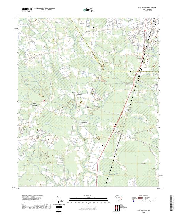
2024 Map of Lake City West
USGS Topo · Published 2024About this map
The boundary between Florence and Williamsburg counties defines the rural landscape of this coastal plain region. At the northeastern corner, Lake City serves as the primary urban center, while the remainder of the territory is characterized by a series of significant crossroads and hamlets. Settlements like Moore Crossroads, Hogeye Crossroads, and Baker Crossroads anchor the agricultural interior, connected by a network of county roads. The landscape is heavily marked by low-lying wetland features including Smith Swamp and Graham Swamp, along with numerous localized bays such as Tupelo Bay and Sandy Bay. In the southern portion of the map, the community of Cades is situated near the Cades Pentecostal Church Graveyard, reflecting the area's long-standing residential and religious roots. The presence of Lake City Municipal Airport underscores the region's modern infrastructure amidst its traditional tobacco and cotton farming heritage.
Find a feature on this map
113 named features on this map. Tap any name to fly to it.
Don’t see what you’re looking for? This feature index may not catch every label — zoom into the map to look around manually.
Map Details
Editions of this 2024 Lake City West Map
This is the sole edition of this map. No revisions or reprints were ever made.
Other maps of this area

1946 · Hyman
USGS Topo · 1:62,500

1946 · Kingstree
USGS Topo · 1:62,500

1946 · Lake City
USGS Topo · 1:62,500

1946 · Indiantown
USGS Topo · 1:62,500

1949 · Georgetown
USGS Topo · 1:250,000

1967 · Georgetown
USGS Topo · 1:250,000

1974 · Georgetown
USGS Topo · 1:250,000

1986 · Kingstree
USGS Topo · 1:100,000
1990 · Hebron Crossroads
USGS Topo · 1:24,000
1990 · Olanta
USGS Topo · 1:24,000