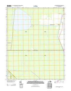
2013 Map of Lake Drummond
USGS Topo · Published 2013About this map
Lake Drummond sits as the central feature of this landscape, its rounded expanse surrounded by a geometric grid of historic drainage channels. These waterways, including Riddick Ditch and Corapeake Ditch, reflect over a century of efforts to manage and navigate the local wetlands. The Dismal Swamp Canal runs along the eastern edge, serving as a primary artery for transport and water management alongside George Washington Hwy S. Small settlements and landings such as Wallaceton, Arbuckle Landing, and the remote Jacks Camp indicate the sparse human footprint in this aqueous environment. The presence of Angle Siding near the canal suggests the historic intersection of rail and water-based commerce, while named ditches like Kim Saunders Ditch and Paw-paw Ditch provide specific reference points for genealogists and local historians tracking land use and family holdings in the region.
Find a feature on this map
30 named features on this map. Tap any name to fly to it.
Don’t see what you’re looking for? This feature index may not catch every label — zoom into the map to look around manually.
Map Details
Editions of this 2013 Lake Drummond Map
This is the sole edition of this map. No revisions or reprints were ever made.
Other maps of this area

1906 · Beckford
USGS Topo · 1:48,000

1907 · Beckford
USGS Topo · 1:62,500

1919 · Suffolk
USGS Topo · 1:62,500

1940 · Beckford
USGS Topo · 1:62,500

1940 · Lake Drummond
USGS Topo · 1:62,500

1940 · South Mills
USGS Topo · 1:62,500

1945 · Lake Drummond
USGS Topo · 1:62,500

1952 · South Mills
USGS Topo · 1:62,500

1953 · Norfolk
USGS Topo · 1:250,000

1954 · Corapeake
USGS Topo · 1:24,000