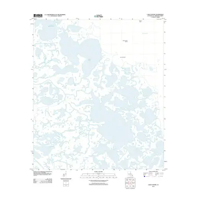
2012 Map of Lake Eugenie
USGS Topo · Published 2012About this map
Lakes of Bayou Marron and the intricate marshlands of Saint Bernard Parish define this coastal landscape, where the land and water exist in a state of constant transition. The map captures a detailed view of the Louisiana delta shortly after the first decade of the millennium, showing the labyrinthine network of waterways including Bayou Marron and the wide expanse of Bobs Lakes. This environment is characterized by thin fingers of land and isolated terrain features like Wild Goose Island and Cat Fish Point, which serve as critical landmarks for navigation in a region dominated by tidal flow. To the south, the historical path of Bayou-la-Loutre winds through the wetlands, reflecting the ancient distributary patterns that have shaped the parish's ecology and coastal heritage. The absence of roads or permanent structures underscores the tidal nature of this territory, where local geography is named for its wildlife and maritime utility, as seen in Redfish Bayou and Pirate Point.
Find a feature on this map
15 named features on this map. Tap any name to fly to it.
Don’t see what you’re looking for? This feature index may not catch every label — zoom into the map to look around manually.
Map Details
Editions of this 2012 Lake Eugenie Map
This is the sole edition of this map. No revisions or reprints were ever made.
Other maps of this area

1893 · Rigolets
USGS Topo · 1:62,500

1893 · Shell Beach
USGS Topo · 1:62,500

1893 · Toulme
USGS Topo · 1:62,500

1895 · Bodreau
USGS Topo · 1:62,500

1935 · Morgan Harbor
USGS Topo · 1:31,680

1936 · Rigolets
USGS Topo · 1:62,500

1939 · Shell Beach
USGS Topo · 1:62,500

1941 · Shell Beach
USGS Topo · 1:62,500

1946 · Oak Mound Bayou
USGS Topo · 1:31,680

1946 · Lake Eugenie
USGS Topo · 1:31,680