
1946 Map of Oak Mound Bayou
USGS Topo · Published 1946About this map
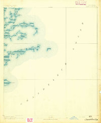
Oak Mound Bayou anchors this coastal survey of St. Bernard Parish, illustrating the complex wetland geography of the Louisiana shoreline in the mid-1930s. Compiled from Army Air Corps aerial photography, the map reveals a fragile network of marshlands and open water where land is defined by name as much as by solid ground. The central waterway system includes Shell Island Lake and Indian Mound Bay, separated from the Gulf waters by landforms like Mud Grass Island. Navigational routes for local fishermen and coastal mariners are detailed through a series of named openings such as Dutchman Pass, Newton Pass, and S W Pass. The inclusion of Anderson Pt and the winding course of Deadmans Bayou provide specific points of reference for those studying the shifting coastline and historical hydrology of this marshy region before significant modern coastal erosion altered these exact land-and-water boundaries.
Find a feature on this map
18 named features on this map. Tap any name to fly to it.
Don’t see what you’re looking for? This feature index may not catch every label — zoom into the map to look around manually.
Map Details
Editions of this 1946 Oak Mound Bayou Map
This is the sole edition of this map. No revisions or reprints were ever made.
Other maps of this area

1893 · Cat Island
USGS Topo · 1:62,500
1893 · Chandeleur
USGS Topo · 1:62,500

1893 · Toulme
USGS Topo · 1:62,500

1895 · Bodreau
USGS Topo · 1:62,500

1935 · Morgan Harbor
USGS Topo · 1:31,680

1935 · Mitchell Keys
USGS Topo · 1:31,680

1946 · Lake Eugenie
USGS Topo · 1:31,680

1946 · Malheureux Point
USGS Topo · 1:31,680

1947 · Lake Eloi
USGS Topo · 1:31,680
1949 · Drum Bay
USGS Topo · 1:31,680