
1947 Map of Lake Eloi
USGS Topo · Published 1947About this map
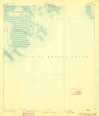
Lake Eloi and the surrounding marshlands of St. Bernard Parish are meticulously documented in this mid-century survey, based on aerial photography from the U.S. Army Air Corps. The landscape is a labyrinth of water and silt, where narrow waterways like Bayou La Loutre and Treasure Pass provided vital transit through the wetlands. Small named outposts such as Christmas Camp, Petre, and Eddie suggest the seasonal or specialized nature of human activity in this tidal environment, likely centered on fishing or trapping. The intricate network of artificial channels, including Engineers Canal, Bakers Canal, and Isaacs Ditch, highlights early efforts to manage water flow and navigation through the delta. From Drum Lake in the north to Lake Athanasio in the south, the map details the fragile transition between the Louisiana mainland and the Gulf of Mexico.
Find a feature on this map
33 named features on this map. Tap any name to fly to it.
Don’t see what you’re looking for? This feature index may not catch every label — zoom into the map to look around manually.
Map Details
Editions of this 1947 Lake Eloi Map
This is the sole edition of this map. No revisions or reprints were ever made.
Other maps of this area
1893 · La Fortuna
USGS Topo · 1:62,500

1893 · Shell Beach
USGS Topo · 1:62,500

1893 · Dime
USGS Topo · 1:62,500

1895 · Bodreau
USGS Topo · 1:62,500

1935 · Morgan Harbor
USGS Topo · 1:31,680

1935 · Lake Athanasio
USGS Topo · 1:31,680

1935 · Lake Calebasse
USGS Topo · 1:31,680

1939 · Shell Beach
USGS Topo · 1:62,500

1941 · Black Bay
USGS Topo · 1:62,500

1941 · Shell Beach
USGS Topo · 1:62,500