
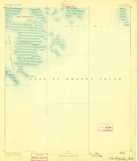
1941 Map of Black Bay
USGS Topo · Published 1941About this map
The low-lying wetlands of Plaquemines and St. Bernard parishes dominate this landscape as it appeared just before the mid-century. A complex network of waterways, including Lake Jean Louis Robin, Lake Calebasse, and the intricate Bayou Jean Louis Robin, defines the interior of this coastal region. The small riverfront settlements of City Price and Happy Jack cling to the narrow strip of higher ground along the Mississippi River, where human activity is most concentrated.
Find a feature on this map
106 named features on this map. Tap any name to fly to it.
Don’t see what you’re looking for? This feature index may not catch every label — zoom into the map to look around manually.
Map Details
Editions of this 1941 Black Bay Map
This is the sole edition of this map. No revisions or reprints were ever made.
Other maps of this area

1891 · Pointe a La Hache
USGS Topo · 1:62,500

1892 · Quarantine
USGS Topo · 1:62,500

1892 · St. Bernard
USGS Topo · 1:62,500

1892 · Pointe a La Hache
USGS Topo · 1:62,500
1893 · La Fortuna
USGS Topo · 1:62,500
1893 · Forts
USGS Topo · 1:62,500

1893 · Shell Beach
USGS Topo · 1:62,500

1893 · Fort Livingston
USGS Topo · 1:62,500

1893 · Dime
USGS Topo · 1:62,500

1895 · Bodreau
USGS Topo · 1:62,500