Old Maps of Encalade, Louisiana
Explore 13 old maps of Encalade, spanning from 1893 to today. These high-resolution historic maps reveal how streets, neighborhoods, landmarks, and natural features evolved over time — perfect for genealogy, metal detecting, research, and local history exploration.
What you can do with these maps:
- See how Encalade changed over time: Compare historical maps to modern-day views to trace roads, homesites, rail lines & more.
- View detailed metadata: Each map includes creators, publishers, year, scale, and archive source.
- Overlay maps with satellite & LiDAR: Visualize the past alongside modern tools to explore terrain & human change.
- Trusted historical sources: Maps sourced from the USGS, Library of Congress, and other archives.
- Access maps your way: View online, download high-res files, or order prints for personal or research use.
Start exploring old maps of Encalade to uncover forgotten places, hidden landmarks, and the deep history beneath your feet.
Encalade, LA maps
(13)- 1893 Map of Dime, 1901 Print
 1893 Dime1901 Print · USGSThe Plaquemines parish riverfront and its vast coastal marshes appear here in the final decade of the nineteenth century. Genealogists can trace the river settlements of Dime and Happy Jack along the N. O. Ft. J. & G. I. R. R. line.2 unique versions available
 - 1941 Map of Black Bay
 1941 Black Bay1941 Print · USGSCoastal Plaquemines Parish and St. Bernard Parish are shown in detail at the end of the 1930s, when river life and marsh navigation defined the region. Researchers can locate riverfront settlements like City Price and Happy Jack or trace the waterways of Lake Coquille and Petain Lagoon.
 - 1944 Map of Black Bay
 1944 Black Bay1944 Print · USGSCoastal Plaquemines Parish and the Mississippi River bank are documented here during the mid-1940s. Genealogists and historians can trace the riverside corridor near City Price and Happy Jack, or explore the complex bayou network including Lake Jean Louis Robin and Belle Isle.
 - 1957 Map of Breton Sound, 1967 Print
 1957 Breton Sound1967 Print · USGSThe Mississippi River delta is captured here in the mid-fifties, showing the fragile marshlands and river-dependent towns of the Louisiana coast. Genealogists and historians can trace riverside settlements like Pointe a la Hache, Pilottown, and Port Sulphur.3 unique versions available
 - 1961 Map of Breton Sound
 1961 Breton Sound1961 Print · USGSThe Louisiana delta and the outer marshes of Plaquemines Parish are captured here at the start of the 1960s. Researchers can trace the river settlements from Davant to Venice, locate isolated stations like Port Eads, and find old sites such as Fort Jackson.
 - 1964 Map of Black Bay
 1964 Black Bay1964 Print · USGSCoastal Plaquemines Parish is mapped here in the mid-1960s, showing a landscape defined by tidal bayous and the emerging offshore energy industry. Researchers can find old riverfront landmarks like Bohemia Cem, the Potash District Camp, and the settlement of Happy Jack.2 unique versions available
 - 1973 Map of Happy Jack, 1976 Print
 1973 Happy Jack1976 Print · USGSThe Mississippi River delta in the early 1970s reveals a unique perspective of riverfront settlements amidst the marshlands of Plaquemines Parish. Researchers can trace the developed corridor of Happy Jack and Port Sulphur, contrasting with the wild expanses of American Bay and the Bohemia State Wildlife Management Area.
 - 1983 Map of Black Bay
 1983 Black Bay1983 Print · USGSCoastal St. Bernard Parish is shown in the early eighties as the Mississippi Delta's fishing villages and industrial infrastructure meet the expanding Gulf sounds. Genealogists and historians can trace family-named sites from Chalmette to Delacroix, including the Southern Railway System and St Bernard State Park.2 unique versions available
 - 2012 Map of Happy Jack, 2012 Print
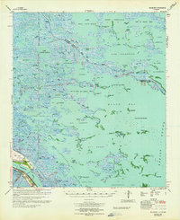
 2012 Happy Jack2012 Print · USGSCovers Encalade, including Happy Jack, Plaquemines Parish, and other nearby areas
 - 2015 Map of Happy Jack, 2015 Print
 2015 Happy Jack2015 Print · USGSCovers Encalade, including Happy Jack, Plaquemines Parish, and other nearby areas
 - 2018 Map of Happy Jack, 2018 Print
 2018 Happy Jack2018 Print · USGSCovers Encalade, including Happy Jack, Plaquemines Parish, and other nearby areas
 - 2020 Map of Happy Jack, 2020 Print
 2020 Happy Jack2020 Print · USGSCovers Encalade, including Happy Jack, Plaquemines Parish, and other nearby areas
 - 2024 Map of Happy Jack, 2024 Print
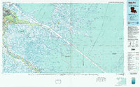
 2024 Happy Jack2024 Print · USGSCoastal Plaquemines Parish appears here in the early twenty-first century as a landscape of riverfront settlements and vast marshlands. Genealogists and local historians can trace the developments at Port Sulphur, Happy Jack, and the Bohemian Cem along the Mississippi levee.
End of results
Showing maps 1-13 of 13
Top cities near Encalade
Frequently asked questions
- What are the different types of historical maps available for Encalade?
- What is the oldest map of Encalade?
- Where can I purchase historical maps of Encalade for my home or office?
- Where can I download high-res historical maps of Encalade?
- Are there historical topographic maps available for Encalade?
- Is there historical aerial imagery available for Encalade?
- Where are historical maps of Encalade sourced from?