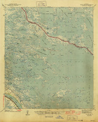
1944 Map of Black Bay
USGS Topo · Published 1944About this map
City Price and Happy Jack anchor the southwestern edge of this coastal landscape, situated along the Mississippi River where the N O & L RR provided a critical rail connection during the mid-20th century. The territory is defined by an intricate network of saltwater bays and lakes, such as Lake Jean Louis Robin, Lake Machias, and Lake Coquille. These water bodies are separated by narrow marshy fingers and connected by named passages like Grand Pass and Dead Duck Pass. The map meticulously records the boundary between St. Bernard and Plaquemines Parishes as it threads through the labyrinth of bayous and lagoons, including Pertain Lagoon and Bottle Lagoon. Named land features like Grise-Bourbe Island and Belle Isle highlight the fragmented nature of the deltaic plain before modern coastal erosion further reshaped the shoreline.
Find a feature on this map
108 named features on this map. Tap any name to fly to it.
Don’t see what you’re looking for? This feature index may not catch every label — zoom into the map to look around manually.
Map Details
Editions of this 1944 Black Bay Map
This is the sole edition of this map. No revisions or reprints were ever made.
Other maps of this area

1891 · Pointe a La Hache
USGS Topo · 1:62,500

1892 · Quarantine
USGS Topo · 1:62,500

1892 · St. Bernard
USGS Topo · 1:62,500

1892 · Pointe a La Hache
USGS Topo · 1:62,500

1893 · La Fortuna
USGS Topo · 1:62,500

1893 · Forts
USGS Topo · 1:62,500

1893 · Shell Beach
USGS Topo · 1:62,500

1893 · Fort Livingston
USGS Topo · 1:62,500

1893 · Dime
USGS Topo · 1:62,500

1895 · Bodreau
USGS Topo · 1:62,500