1960s Maps of Encalade, Louisiana
Explore 2 historic maps of Encalade from the 1960s. These maps offer a rare glimpse into what life looked like during the 1960s — showing old roads, neighborhoods, homes, and landmarks that have changed or disappeared over time.
Whether you're researching your family's past, planning a metal detecting trip, or studying how Encalade's landscape evolved across the 1960s, these high-resolution maps are a powerful tool for exploring the history of this region.
- Focus on a specific era: All maps on this page are from the 1960s, giving you a focused view of this time period.
- See what’s changed: Compare century-old streets, trails, and buildings to today's modern landscape using overlays and satellite layers.
- Research with precision: Use these maps for genealogy, historical research, land use analysis, or educational projects.
- View, download, or print: Maps are fully viewable online in high resolution, and can be downloaded or printed for your own records.
Start exploring Encalade's history through authentic maps from the 1960s. This is your window into the past.
Encalade, LA maps
(2)- 1961 Map of Breton Sound
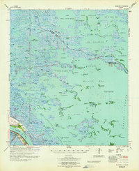
 1961 Breton Sound1961 Print · USGSThe Louisiana delta and the outer marshes of Plaquemines Parish are captured here at the start of the 1960s. Researchers can trace the river settlements from Davant to Venice, locate isolated stations like Port Eads, and find old sites such as Fort Jackson.
 - 1964 Map of Black Bay
 1964 Black Bay1964 Print · USGSCoastal Plaquemines Parish is mapped here in the mid-1960s, showing a landscape defined by tidal bayous and the emerging offshore energy industry. Researchers can find old riverfront landmarks like Bohemia Cem, the Potash District Camp, and the settlement of Happy Jack.2 unique versions available
End of results
Showing maps 1-2 of 2
Top cities near Encalade
Frequently asked questions
- What are the different types of historical maps available for Encalade?
- What is the oldest map of Encalade?
- Where can I purchase historical maps of Encalade for my home or office?
- Where can I download high-res historical maps of Encalade?
- Are there historical topographic maps available for Encalade?
- Is there historical aerial imagery available for Encalade?
- Where are historical maps of Encalade sourced from?