
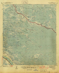
1935 Map of Lake Athanasio
USGS Topo · Published 1935About this map
Lake Athanasio and the surrounding marshlands of St. Bernard Parish are captured here in high detail during the mid-1930s. This survey, compiled from early Air Corps aerial photography, reveals the intricate labyrinth of waterways where the Chandeleur Sound meets the interior wetlands. The landscape is defined by its numerous small bays and passes, including the oddly named Seven Dollar Bay and the nearby Seven Dollar Bayou. The southern extent of the sheet marks the border with Plaquemines Parish near Mozambique Pt, showing the coastal boundary as it existed before decades of shoreline recession. Local mariners and historians will find interest in the specific configurations of features like Pass Fernandea and St. Helena Bay, which reflect the hydrology of the Louisiana coast prior to modern larger-scale engineering projects.
Find a feature on this map
23 named features on this map. Tap any name to fly to it.
Don’t see what you’re looking for? This feature index may not catch every label — zoom into the map to look around manually.
Map Details
Editions of this 1935 Lake Athanasio Map
This is the sole edition of this map. No revisions or reprints were ever made.
Other maps of this area

1893 · La Fortuna
USGS Topo · 1:62,500

1893 · Shell Beach
USGS Topo · 1:62,500

1893 · Dime
USGS Topo · 1:62,500

1895 · Bodreau
USGS Topo · 1:62,500

1935 · Morgan Harbor
USGS Topo · 1:31,680

1935 · Lake Calebasse
USGS Topo · 1:31,680

1939 · Shell Beach
USGS Topo · 1:62,500

1941 · Black Bay
USGS Topo · 1:62,500

1941 · Shell Beach
USGS Topo · 1:62,500
1944 · Black Bay
USGS Topo · 1:62,500