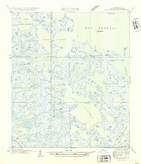
1954 Map of Lake Eugenie
USGS Topo · Published 1954About this map
Indian Mound stands as a prominent landmark in this 1954 survey of St. Bernard Parish, highlighting the early human presence in the Louisiana marshlands. This intricate network of coastal waterways and wetlands, including Lake Eugenie and Lake of the Mound, reflects the complex geography of the Mississippi River delta before significant modern alterations. The map identifies specific landing points and navigation markers such as Pirate Pt, Eugene, and Lawson, which served as vital reference points for local trappers, fishermen, and boaters navigating the labyrinthine passages of Bayou Marron and Biloxi Bayou. The distribution of these named points and bayous provides an essential record of mid-century coastal Louisiana, where the land and water were in constant flux, and seasonal camps or small settlements like False were integrated into the tidal landscape.
Find a feature on this map
20 named features on this map. Tap any name to fly to it.
Don’t see what you’re looking for? This feature index may not catch every label — zoom into the map to look around manually.
Map Details
Editions of this 1954 Lake Eugenie Map
This is the sole edition of this map. No revisions or reprints were ever made.
Other maps of this area

1893 · Rigolets
USGS Topo · 1:62,500

1893 · Shell Beach
USGS Topo · 1:62,500

1893 · Toulme
USGS Topo · 1:62,500

1895 · Bodreau
USGS Topo · 1:62,500

1935 · Morgan Harbor
USGS Topo · 1:31,680

1936 · Rigolets
USGS Topo · 1:62,500

1939 · Shell Beach
USGS Topo · 1:62,500

1941 · Shell Beach
USGS Topo · 1:62,500

1946 · Oak Mound Bayou
USGS Topo · 1:31,680

1946 · Lake Eugenie
USGS Topo · 1:31,680