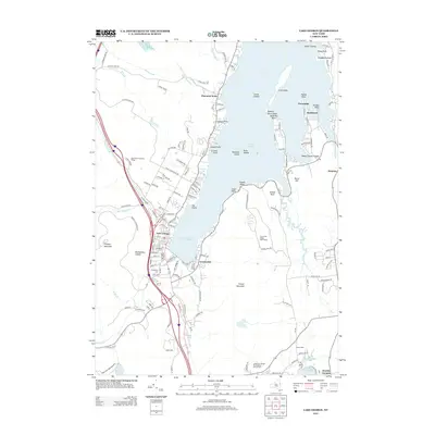
2013 Map of Lake George
USGS Topo · Published 2013About this map
Lake George dominates the landscape as it appeared in the early 21st century, with its intricate shoreline of points and islands defining the local geography. The village of Lake George serves as a central hub, flanked by the steep elevations of Prospect Mountain and Rattlesnake Cobble to the west and the massive profile of French Mountain to the east. This survey captures the high-density residential and resort development along the southern basin, stretching from Crosbyside around to the seasonal communities of Cleverdale and Rockhurst on the eastern shore. Genealogists and local historians can locate several burial grounds, including the Caldwell Cem, Evergreen Cem, and the more remote Scotch Cem near Oneida Corners. The map also illustrates the transition from the developed village center to the protected wilds of the Adirondack Park Preserve, showing the network of local roads such as Diamond Point Rd and Truesdale Hill Rd that navigate the varied terrain.
Find a feature on this map
144 named features on this map. Tap any name to fly to it.
Don’t see what you’re looking for? This feature index may not catch every label — zoom into the map to look around manually.
Map Details
Editions of this 2013 Lake George Map
This is the sole edition of this map. No revisions or reprints were ever made.
Other maps of this area

1895 · North Creek
USGS Topo · 1:62,500

1895 · Glens Falls
USGS Topo · 1:62,500

1897 · Bolton
USGS Topo · 1:62,500

1897 · Glens Falls
USGS Topo · 1:62,500

1897 · North Creek
USGS Topo · 1:62,500

1900 · Bolton
USGS Topo · 1:62,500

1903 · Luzerne
USGS Topo · 1:62,500

1938 · Glens Falls
USGS Topo · 1:62,500

1947 · Glens Falls
USGS Topo · 1:62,500

1950 · Glens Falls
USGS Topo · 1:250,000