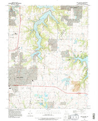
1990 Map of Lake Jacomo
USGS Topo · Published 1995About this map
Fleming County Park dominates the center of this landscape, anchored by the long, branching waters of Lake Jacomo. Surrounding the reservoir, the terrain transitions into the expanding residential and municipal fringes of Lees Summit to the west and Blue Springs to the north. This 1990 revision, based on imagery dating back to 1955 and planetable surveys from 1934, illustrates a suburbanizing Missouri landscape where old farm roads like Hagen Rd and Colborn Road are integrated into a modern grid. To the south, the James A. Reed Memorial State Wildlife Area preserves a dense concentration of smaller water bodies including Plover Lake, Jackrabbit Lake, and Gopher Lake. The map captures a moment of balance between large-scale recreational development and the persistent natural drainage of the Little Blue River.
Find a feature on this map
26 named features on this map. Tap any name to fly to it.
Don’t see what you’re looking for? This feature index may not catch every label — zoom into the map to look around manually.
Map Details
Editions of this 1990 Lake Jacomo Map
This is the sole edition of this map. No revisions or reprints were ever made.
Other maps of this area

1887 · Harrisonville
USGS Topo · 1:125,000

1892 · Harrisonville
USGS Topo · 1:125,000

1894 · Harrisonville
USGS Topo · 1:125,000

1894 · Independence
USGS Topo · 1:125,000

1933 · Blue Springs
USGS Topo · 1:24,000

1934 · Oak Grove
USGS Topo · 1:24,000

1934 · Independence
USGS Topo · 1:24,000

1934 · Lees Summit
USGS Topo · 1:24,000

1934 · Woods Chapel
USGS Topo · 1:24,000

1935 · Tarsney
USGS Topo · 1:24,000