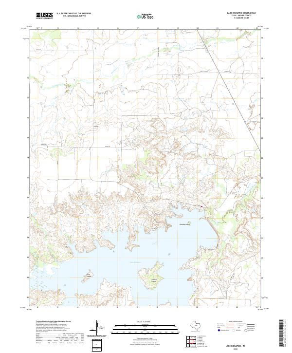
2022 Map of Lake Kickapoo
USGS Topo · Published 2022About this map
Lake Kickapoo dominates this portion of Archer County, where its irregular shoreline is punctuated by notable landforms like Pancake Island, Long Island, and Council Island. The landscape is a network of watercourses and rural thoroughfares, with the N Fork Little Wichita River and various creeks such as Holliday Cr and Slippery Cr feeding into the reservoir system. The terrestrial layout is defined by a grid of ranch roads and local connectors, including Wilson Ranch Rd, Gose City Rd, and Black Flat Rd. Modern land use is evident in the residential developments along the eastern lakefront, where streets like Coyote Call Rd and Waters Edge Rd line the water's edge. This detailed survey provides a clear view of the modern infrastructure and natural drainage patterns surrounding one of North Texas's significant water resources.
Find a feature on this map
25 named features on this map. Tap any name to fly to it.
Don’t see what you’re looking for? This feature index may not catch every label — zoom into the map to look around manually.
Map Details
Editions of this 2022 Lake Kickapoo Map
This is the sole edition of this map. No revisions or reprints were ever made.
Other maps of this area

1931 · Archer City
USGS Topo · 1:62,500

1932 · Dundee
USGS Topo · 1:62,500

1954 · Wichita Falls
USGS Topo · 1:250,000

1957 · Wichita Falls West
USGS Topo · 1:62,500

1958 · Wichita Falls
USGS Topo · 1:250,000

1963 · Dundee
USGS Topo · 1:24,000

1963 · Dundee SW
USGS Topo · 1:24,000

1964 · Dundee SE
USGS Topo · 1:24,000

1964 · Archer City West
USGS Topo · 1:24,000
1966 · Mankins
USGS Topo · 1:24,000