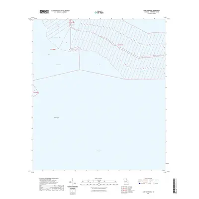
2021 Map of Lake La Graisse
USGS Topo · Published 2021About this map
Terrebonne Bay dominates the southern landscape of this coastal quadrangle, where the fluid interface between salt marsh and open water is meticulously documented. The northern reach of the map is defined by a complex network of waterways, including Lake La Graisse and the winding Bayou Jose, illustrating the intricate drainage patterns of the Louisiana delta. The inclusion of the Public Land Survey System (PLSS) grid reveals a high density of narrow, numbered land claims along the bayous, a traditional French land-use pattern where long lots provided water access to numerous settlers. Navigational channels like Seabreeze Pass and Pass Barre provide passage through the coastal fringe, while the submerged contours of Bay Lost Reef and the prominent protrusion of Point Meshe mark the shifting boundaries of the Terrebonne Parish shoreline.
Find a feature on this map
10 named features on this map. Tap any name to fly to it.
Don’t see what you’re looking for? This feature index may not catch every label — zoom into the map to look around manually.
Map Details
Editions of this 2021 Lake La Graisse Map
This is the sole edition of this map. No revisions or reprints were ever made.
Other maps of this area

1894 · Timbalier
USGS Topo · 1:62,500

1894 · Lake Felicity
USGS Topo · 1:62,500

1894 · Dulac
USGS Topo · 1:62,500

1935 · Cocodrie
USGS Topo · 1:31,680

1935 · Bourbeux
USGS Topo · 1:31,680

1935 · Timbalier Island
USGS Topo · 1:31,680

1935 · Lake Quitman
USGS Topo · 1:31,680

1939 · Lake Felicity
USGS Topo · 1:62,500

1941 · Lake Felicity
USGS Topo · 1:62,500

1941 · Dulac
USGS Topo · 1:62,500