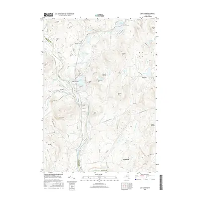
2016 Map of Lake Luzerne
USGS Topo · Published 2016About this map
The confluence of the Hudson River and the Sacandaga River defines the community center of Hadley and the neighboring village of Lake Luzerne. This area of the Luzerne Mountains in the mid-2010s shows a landscape of clustered lakeside settlements and mountain peaks. For those researching local families, the map identifies several burial sites including the Old Methodist Cem and the Leavens Cem near the banks of the Hudson. The terrain is marked by numerous water bodies like Fourth Lake, Lake Vanare, and the Wilkie Reservoir, which sit among heights such as Rockwell Hill and Mt Anthony. The distribution of roads like Corinth Rd and Old River Rd illustrates how development has followed the natural contours of the river valleys and the edges of the Adirondack foothills.
Find a feature on this map
113 named features on this map. Tap any name to fly to it.
Don’t see what you’re looking for? This feature index may not catch every label — zoom into the map to look around manually.
Map Details
Editions of this 2016 Lake Luzerne Map
This is the sole edition of this map. No revisions or reprints were ever made.
Other maps of this area

1895 · Glens Falls
USGS Topo · 1:62,500

1897 · Glens Falls
USGS Topo · 1:62,500

1900 · Schuylerville
USGS Topo · 1:62,500

1902 · Saratoga
USGS Topo · 1:62,500

1903 · Luzerne
USGS Topo · 1:62,500

1935 · Gansevoort
USGS Topo · 1:24,000

1935 · Corinth
USGS Topo · 1:24,000

1938 · Glens Falls
USGS Topo · 1:62,500
1940 · Schuylerville
USGS Topo · 1:62,500

1942 · Saratoga
USGS Topo · 1:62,500