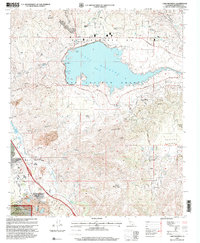
1997 Map of Lake Mathews
USGS Topo · Published 2000About this map
Lake Mathews dominates the northern landscape of this Riverside County region, held by the engineering of Mathews Dam and its associated Outlet Tower. This late-twentieth-century survey documents a transition between industrial extraction and historical preservation. To the south, the Temescal Wash corridor serves as a hub for both ancient and modern activity, featuring the Indian Pictographs Historical Marker near the settlement of Arcilla and several prominent Claypit sites.
Find a feature on this map
33 named features on this map. Tap any name to fly to it.
Don’t see what you’re looking for? This feature index may not catch every label — zoom into the map to look around manually.
Map Details
Editions of this 1997 Lake Mathews Map
This is the sole edition of this map. No revisions or reprints were ever made.
Other maps of this area

1901 · Southern California Sheet No. 1
USGS Topo · 1:250,000

1901 · Elsinore
USGS Topo · 1:125,000

1901 · Riverside
USGS Topo · 1:62,500

1902 · Corona
USGS Topo · 1:125,000

1904 · Southern California Sheet No. 1
USGS Topo · 1:250,000

1942 · Lake Elsinore
USGS Topo · 1:62,500
1942 · Corona and Vicinity
USGS Topo · 1:31,680
1942 · Riverside and Vicinity
USGS Topo · 1:31,680

1942 · Santiago Peak
USGS Topo · 1:62,500

1942 · Corona
USGS Topo · 1:62,500