
1942 Map of Corona
USGS Topo · Published 1947About this map
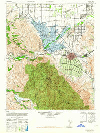
The Corona region during the 1940s is defined by a landscape transitioning from vast citrus groves and ranches to institutional and flood-control infrastructure. At the heart of the sheet lies the burgeoning street grid of the "Circle City," while to the north, the California Institution for Men and Los Serranos Country Club occupy large tracts near Chino Creek. The importance of water management in the Santa Ana River basin is evident in the presence of the Prado Dam and the expansive Prado Flood Control Basin, which reshaped the geography near the junctions of Riverside, San Bernardino, and Orange counties.
Find a feature on this map
75 named features on this map. Tap any name to fly to it.
Don’t see what you’re looking for? This feature index may not catch every label — zoom into the map to look around manually.
Map Details
Editions of this 1942 Corona Map
2 editions found
Other maps of this area

1894 · Pomona
USGS Topo · 1:62,500

1896 · Santa Ana
USGS Topo · 1:62,500

1896 · Anaheim
USGS Topo · 1:62,500

1896 · San Bernardino
USGS Topo · 1:62,500

1897 · Pomona
USGS Topo · 1:62,500

1897 · Cucamonga
USGS Topo · 1:62,500

1898 · Pomona
USGS Topo · 1:62,500

1898 · San Bernardino
USGS Topo · 1:62,500

1898 · Anaheim
USGS Topo · 1:62,500

1900 · Cucamonga
USGS Topo · 1:62,500