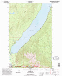
1994 Map of Lake Mc Donald West
USGS Topo · Published 1997About this map
Mc Donald Lake dominates this landscape, its western shores traced by the famous Going To The Sun Road. This 1990s revision by the Forest Service captures the developed hub of Apgar at the lake's foot, where the Park Headquarters and West Entrance Station manage the influx of visitors to Glacier National Park. To the north, the Lake McDonald Hotel stands as a primary destination, while the Fish Creek Park Service area and nearby Amphitheater mark the established recreational infrastructure of the era.
Find a feature on this map
26 named features on this map. Tap any name to fly to it.
Don’t see what you’re looking for? This feature index may not catch every label — zoom into the map to look around manually.
Map Details
Editions of this 1994 Lake Mc Donald West Map
This is the sole edition of this map. No revisions or reprints were ever made.
Other maps of this area

1904 · Chief Mountain
USGS Topo · 1:125,000

1906 · Kintla Lakes
USGS Topo · 1:125,000

1914 · Nyack
USGS Topo · 1:125,000

1938 · Chief Mountain
USGS Topo · 1:125,000

1938 · Kintla Lakes
USGS Topo · 1:125,000

1943 · Kalispell
USGS Topo · 1:125,000

1957 · Kalispell
USGS Topo · 1:250,000

1960 · Kalispell
USGS Topo · 1:250,000

1960 · Cut Bank
USGS Topo · 1:250,000

1961 · Kalispell
USGS Topo · 1:250,000