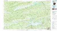
1982 Map of Lake Ouachita
USGS Topo · Published 1982About this map
Ouachita National Forest dominates this topographic study of West Central Arkansas, revealing a landscape defined by the parallel ridges of the Ouachita Mountains. The map provides a detailed view of the massive Lake Ouachita and the surrounding timberlands, illustrating the region's transition from the hydraulic power of the Ouachita River to the recreation-driven economies of the early 1980s. To the north, the Petit Jean River and Dutch Creek carve through valleys between Bogus Ridge and Fourche Mountain.
Find a feature on this map
51 named features on this map. Tap any name to fly to it.
Don’t see what you’re looking for? This feature index may not catch every label — zoom into the map to look around manually.
Map Details
Editions of this 1982 Lake Ouachita Map
This is the sole edition of this map. No revisions or reprints were ever made.
Other maps of this area

1879 · Poteau Mountain
USGS Topo · 1:62,500

1879 · Mountain Home
USGS Topo · 1:62,500

1887 · Poteau Mountain #1
USGS Topo · 1:62,500

1887 · Magazine Mountain #4
USGS Topo · 1:62,500

1887 · Mount Ida #2
USGS Topo · 1:62,500

1887 · Magazine Mountain #3
USGS Topo · 1:62,500

1887 · Magazine Mountain
USGS Topo · 1:62,500

1888 · Dardanelle #4
USGS Topo · 1:62,500

1888 · Dardanelle #3
USGS Topo · 1:62,500

1889 · Morrilton No. 3
USGS Topo · 1:62,500