
1879 Map of Mountain Home
USGS Topo · Published 1879About this map
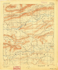
Calico Mountain and the high ridges of the Ozark interior dominate this early topographic study, produced under the direction of J.W. Powell. The survey focuses on a narrow band of complex terrain, where drainage patterns like Chinkapin Br. and Jake's Cr. carve deep into the plateaus. A notable family-named landmark, Cotton's Cove, sits tucked between the peaks of Rich Mountain and Flat Top Mt., suggesting early mountain homesteads or hollows established decades before modern infrastructure reached this part of Logan. The work of topographer Henry Gannett reveals the steep relief and hydrological network of Cove Creek and Shoal Creek during a period of primary geographical documentation in Arkansas.
Find a feature on this map
8 named features on this map. Tap any name to fly to it.
Don’t see what you’re looking for? This feature index may not catch every label — zoom into the map to look around manually.
Map Details
Editions of this 1879 Mountain Home Map
This is the sole edition of this map. No revisions or reprints were ever made.
Other maps of this area

1887 · Magazine Mountain #1
USGS Topo · 1:62,500

1887 · Magazine Mountain #4
USGS Topo · 1:62,500

1887 · Mount Ida #2
USGS Topo · 1:62,500

1887 · Magazine Mountain #2
USGS Topo · 1:62,500

1887 · Magazine Mountain #3
USGS Topo · 1:62,500

1887 · Magazine Mountain
USGS Topo · 1:62,500

1888 · Dardanelle #2
USGS Topo · 1:62,500

1888 · Dardanelle #3
USGS Topo · 1:62,500

1890 · Magazine Mountain
USGS Topo · 1:125,000
1890 · Mount Ida
USGS Topo · 1:125,000