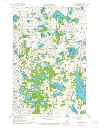
1966 Map of Lake Park SW
USGS Topo · Published 1968About this map
The boundary between Clay and Becker counties runs through a glaciated landscape defined by an exceptional density of kettle lakes and wetlands during the mid-1960s. The dominance of family-named water bodies, such as Christ Olson Lake, Knudson Lake, and Thorson Lake, suggests a history of Scandinavian settlement and land ownership in the townships of Eglon and Lake Park. While the larger Upper Cormorant Lake anchors the southeastern corner, the interior is a network of smaller basins and marshlands, including the Lunde State Wildlife Management Area.
Find a feature on this map
50 named features on this map. Tap any name to fly to it.
Don’t see what you’re looking for? This feature index may not catch every label — zoom into the map to look around manually.
Map Details
Editions of this 1966 Lake Park SW Map
This is the sole edition of this map. No revisions or reprints were ever made.
Other maps of this area

1914 · Pelican Rapids
USGS Topo · 1:62,500

1917 · Pelican Rapids
USGS Topo · 1:62,500

1919 · Barnesville
USGS Topo · 1:62,500

1919 · Hawley
USGS Topo · 1:62,500

1952 · Barnesville
USGS Topo · 1:62,500

1953 · Fargo
USGS Topo · 1:250,000

1956 · Fargo
USGS Topo · 1:250,000
1966 · Hawley SE
USGS Topo · 1:24,000
1966 · Big Cormorant Lake
USGS Topo · 1:24,000
1966 · Dale
USGS Topo · 1:24,000