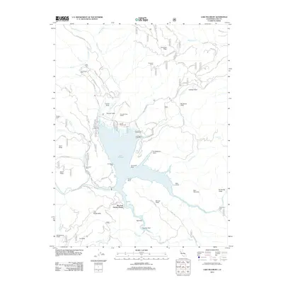
2012 Map of Lake Pillsbury
USGS Topo · Published 2012About this map
Lake Pillsbury serves as the central focal point of this Northern California landscape, where the waters of the Eel River and the Rice Fork meet. The 2012 map illustrates a geography defined by recreational and seasonal settlements, including Rice Fork Summer Homes, Lake Pillsbury Ranch, and the Soda Creek Resort. Transportation into this mountainous region is facilitated by routes like Elk Mountain Rd and the Gravelly Valley Airport, which sits on the northern shore near the Oak Flat Campground.
Find a feature on this map
93 named features on this map. Tap any name to fly to it.
Don’t see what you’re looking for? This feature index may not catch every label — zoom into the map to look around manually.
Map Details
Editions of this 2012 Lake Pillsbury Map
This is the sole edition of this map. No revisions or reprints were ever made.
Other maps of this area

1922 · Hullville
USGS Topo · 1:62,500

1929 · Eden Valley
USGS Topo · 1:62,500

1943 · Pomo
USGS Topo · 1:62,500

1951 · Lake Pillsbury
USGS Topo · 1:62,500

1952 · Hull Mountain
USGS Topo · 1:62,500

1952 · Eden Valley
USGS Topo · 1:62,500

1957 · Ukiah
USGS Topo · 1:250,000

1960 · Ukiah
USGS Topo · 1:250,000
1960 · Potter Valley
USGS Topo · 1:24,000

1960 · Potter Valley
USGS Topo · 1:62,500