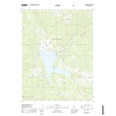
2018 Map of Lake Pillsbury
USGS Topo · Published 2018About this map
Lake Pillsbury forms the geographic centerpiece of this Northern California landscape, where the Eel River and the Rice Fork converge. The area is defined by its recreational and utility infrastructure, featuring the Gravelly Valley Airport and several access points such as Oak Flat C.G. and the Pines Resort. The rugged surroundings of the Mendocino National Forest are marked by significant landmarks like Coyote Rocks and the heights of Bear Mtn. Settlement is sparse, represented by the small locality of Cabbage Patch and various summer home sites. A network of specialized roads, including the Pillsbury-Indian Dick and numerous 4X4 and OHV routes like Powder House OHV, indicates a landscape primarily utilized for timber management, power generation, and backcountry exploration. Notable landforms such as Graveyard Point and McLeod Ridge break the shoreline of the reservoir, reflecting a 21st-century management of these vital Lake County waterways.
Find a feature on this map
104 named features on this map. Tap any name to fly to it.
Don’t see what you’re looking for? This feature index may not catch every label — zoom into the map to look around manually.
Map Details
Editions of this 2018 Lake Pillsbury Map
This is the sole edition of this map. No revisions or reprints were ever made.
Other maps of this area

1922 · Hullville
USGS Topo · 1:62,500

1929 · Eden Valley
USGS Topo · 1:62,500

1943 · Pomo
USGS Topo · 1:62,500

1951 · Lake Pillsbury
USGS Topo · 1:62,500

1952 · Hull Mountain
USGS Topo · 1:62,500

1952 · Eden Valley
USGS Topo · 1:62,500

1957 · Ukiah
USGS Topo · 1:250,000

1960 · Ukiah
USGS Topo · 1:250,000
1960 · Potter Valley
USGS Topo · 1:24,000

1960 · Potter Valley
USGS Topo · 1:62,500