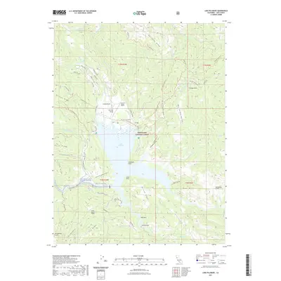
2021 Map of Lake Pillsbury
USGS Topo · Published 2021About this map
Lake Pillsbury serves as the central hub for this portion of the Mendocino National Forest, where the waters of the Rice Fork and the Eel Wild and Scenic River converge. The landscape is defined by the sharp relief of Boardman Ridge and McLeod Ridge, which hem in the seasonal residences and recreation sites along the shoreline. The mapping shows a distinct concentration of activity at the northern end of the reservoir, including the Gravelly Valley Airport and the historic Pillsbury Ranch. Notable for its remote road network, the area is accessible via routes like the Van Arsdale-Pillsbury road and the Lake Co. Rd. (Scott Dam). Landowners and genealogists will find interest in the precise locations of the Rice Fork Summer Homes and small outposts such as Cabbage Patch. The map also documents numerous water sources vital to the local ecology, such as Logan Spring and Dead Cow Spring.
Find a feature on this map
73 named features on this map. Tap any name to fly to it.
Don’t see what you’re looking for? This feature index may not catch every label — zoom into the map to look around manually.
Map Details
Editions of this 2021 Lake Pillsbury Map
This is the sole edition of this map. No revisions or reprints were ever made.
Other maps of this area

1922 · Hullville
USGS Topo · 1:62,500

1929 · Eden Valley
USGS Topo · 1:62,500

1943 · Pomo
USGS Topo · 1:62,500

1951 · Lake Pillsbury
USGS Topo · 1:62,500

1952 · Hull Mountain
USGS Topo · 1:62,500

1952 · Eden Valley
USGS Topo · 1:62,500

1957 · Ukiah
USGS Topo · 1:250,000

1960 · Ukiah
USGS Topo · 1:250,000
1960 · Potter Valley
USGS Topo · 1:24,000

1960 · Potter Valley
USGS Topo · 1:62,500