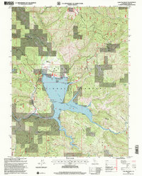
1996 Map of Lake Pillsbury
USGS Topo · Published 2001About this map
Lake Pillsbury serves as the central focal point of this Mendocino National Forest landscape, where the waters of the Eel River and several creek systems are held by the Scott Dam. The reservoir's shoreline is dotted with recreation and ranching history, including the Gravelly Valley Navy Camp Recreation Area and various private holdings such as Lake Pillsbury Ranch, Fuller Ranch, and Faraway Ranch. This survey captures the region as a hub for outdoor activity and remote residency, featuring established sites like Soda Creek Resort and the Lake Pillsbury Pines Resort. High-altitude terrain, including Bear Mountain and Boardman Ridge, encloses the valley, while smaller geographical features like Little Squaw Valley and Coyote Rocks define the intricate topography of northern Lake County.
Find a feature on this map
60 named features on this map. Tap any name to fly to it.
Don’t see what you’re looking for? This feature index may not catch every label — zoom into the map to look around manually.
Map Details
Editions of this 1996 Lake Pillsbury Map
This is the sole edition of this map. No revisions or reprints were ever made.
Other maps of this area

1922 · Hullville
USGS Topo · 1:62,500

1929 · Eden Valley
USGS Topo · 1:62,500

1943 · Pomo
USGS Topo · 1:62,500

1951 · Lake Pillsbury
USGS Topo · 1:62,500

1952 · Hull Mountain
USGS Topo · 1:62,500

1952 · Eden Valley
USGS Topo · 1:62,500

1957 · Ukiah
USGS Topo · 1:250,000

1960 · Ukiah
USGS Topo · 1:250,000
1960 · Potter Valley
USGS Topo · 1:24,000

1960 · Potter Valley
USGS Topo · 1:62,500