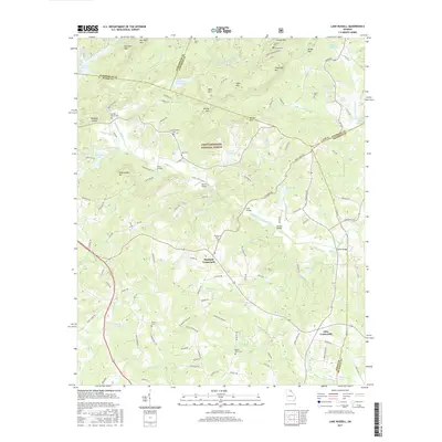
2017 Map of Lake Russell
USGS Topo · Published 2017About this map
The Chattahoochee National Forest dominates the upper half of this northeast Georgia landscape, where the Middle Fork Broad River and its tributaries carve through a complex series of ridges. Small rural communities like Pinefield Crossroads and Odis Crossroads mark the intersections of a road network that transitions from forest service routes to established county roads like Homer Rd. The map reveals a high concentration of family and community burial sites, including the Austin Cem, Broad River Cem, and Leatherwood Cem, reflecting the deep generational roots in Banks and Habersham counties. Water management is a defining feature of the era, seen in the string of numbered reservoirs and named bodies like Lake Russell and Nancy Town Lake. Historic crossing points are well-preserved in the record, with Kesler Bridge, Line Bridge, and Hooper Bridge spanning the river forks and creeks that define the local topography.
Find a feature on this map
127 named features on this map. Tap any name to fly to it.
Don’t see what you’re looking for? This feature index may not catch every label — zoom into the map to look around manually.
Map Details
Editions of this 2017 Lake Russell Map
This is the sole edition of this map. No revisions or reprints were ever made.
Other maps of this area

1886 · Dahlonega
USGS Topo · 1:125,000

1886 · Walhalla
USGS Topo · 1:125,000

1891 · Gainesville
USGS Topo · 1:125,000

1891 · Carnesville
USGS Topo · 1:125,000

1892 · Dahlonega
USGS Topo · 1:125,000

1892 · Walhalla
USGS Topo · 1:125,000

1896 · Walhalla
USGS Topo · 1:125,000

1896 · Dahlonega
USGS Topo · 1:125,000

1903 · Dahlonega
USGS Topo · 1:125,000

1954 · Greenville
USGS Topo · 1:250,000