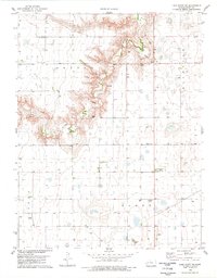
1978 Map of Lake Scott SW
USGS Topo · Published 1978About this map
Ladder Creek carves a sharp, winding canyon through the high plains of western Kansas, creating a distinct topographical break in an otherwise uniform agricultural landscape. This 1970s survey documents the rural character of Scott County, where the small community of Beaver Flats and the nearby Beaver Flats Sch served the surrounding farmsteads. The map highlights the area's economic infrastructure, from the industrial Feedlot operations and numerous Gravel Pits along the creek bluffs to the Pipelines traversing the townships. Local communication and aviation are represented by the Radio Tower (KFLA) and the Buehler Airfield, providing a detailed look at the specialized landmarks that anchored this prairie region during the late twentieth century.
Find a feature on this map
16 named features on this map. Tap any name to fly to it.
Don’t see what you’re looking for? This feature index may not catch every label — zoom into the map to look around manually.
Map Details
Editions of this 1978 Lake Scott SW Map
This is the sole edition of this map. No revisions or reprints were ever made.
Other maps of this area

1939 · Lake Mc Bride
USGS Topo · 1:24,000

1939 · Sandon
USGS Topo · 1:62,500

1939 · Pence
USGS Topo · 1:62,500

1940 · Scott City
USGS Topo · 1:62,500

1941 · Modoc
USGS Topo · 1:62,500

1941 · Pence
USGS Topo · 1:62,500

1942 · Sandon
USGS Topo · 1:62,500

1942 · Lake Mc Bride
USGS Topo · 1:31,680

1951 · Scott City
USGS Topo · 1:62,500

1951 · Modoc
USGS Topo · 1:62,500