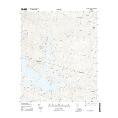
2014 Map of Lake Sinclair East
USGS Topo · Published 2014About this map
Lake Sinclair dominates the landscape at the boundary of Hancock and Baldwin counties, where complex shorelines meet the historic Oconee River. This contemporary survey shows the extensive residential development and road networks that have grown around the impoundment, including Lake Island Dr and River Ridge Tr. Despite modern utility, the map is a significant resource for genealogists, as it preserves the locations of numerous family burial grounds that predate the reservoir. Key sites include the Island Creek Baptist Church Cem and several private plots like the James Butts Family Cem and Simmons Family Cem. The southern reach of the map transitions toward Sandtown, where the river geography includes Furman Shoals and Carter Island, while the Baldwin County Airport serves as a modern landmark near the water's edge.
Find a feature on this map
123 named features on this map. Tap any name to fly to it.
Don’t see what you’re looking for? This feature index may not catch every label — zoom into the map to look around manually.
Map Details
Editions of this 2014 Lake Sinclair East Map
This is the sole edition of this map. No revisions or reprints were ever made.
Other maps of this area

1912 · Milledgeville
USGS Topo · 1:62,500

1953 · Athens
USGS Topo · 1:250,000

1958 · Athens
USGS Topo · 1:250,000

1959 · Athens
USGS Topo · 1:250,000

1963 · Athens
USGS Topo · 1:250,000

1972 · Shoulderbone
USGS Topo · 1:24,000

1972 · Meda
USGS Topo · 1:24,000
1972 · Devereux
USGS Topo · 1:24,000
1972 · Browns Crossing
USGS Topo · 1:24,000
1972 · Lake Sinclair West
USGS Topo · 1:24,000