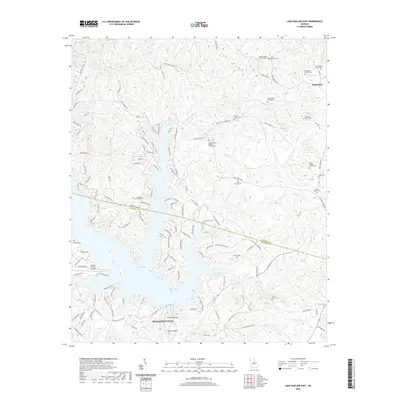
2020 Map of Lake Sinclair East
USGS Topo · Published 2020About this map
Lake Sinclair dominates this landscape northeast of Milledgeville, where the convoluted shoreline of the reservoir meets the historic rural boundaries of Baldwin and Hancock counties. The map documents a blend of mid-century recreation and much older family roots, showing modern residential roads like Shillelagh Cir and Lakeshore Cir NE alongside numerous private burial grounds. Genealogists will find a wealth of family history preserved in labels for the James Butts Family Cem, Lillie Rhodes Cem, and Quinn-Arnold Family Cem. The Oconee River flows south toward Furman Shoals, while the northern reaches of the quadrangle are defined by watercourses like Sandy Run and Island Cr, which hosts the Island Creek Baptist Church. Near the southwestern corner, the Baldwin County Airport serves as a modern landmark in a region otherwise characterized by its many creeks and family-named cemeteries.
Find a feature on this map
135 named features on this map. Tap any name to fly to it.
Don’t see what you’re looking for? This feature index may not catch every label — zoom into the map to look around manually.
Map Details
Editions of this 2020 Lake Sinclair East Map
This is the sole edition of this map. No revisions or reprints were ever made.
Other maps of this area

1912 · Milledgeville
USGS Topo · 1:62,500

1953 · Athens
USGS Topo · 1:250,000

1958 · Athens
USGS Topo · 1:250,000

1959 · Athens
USGS Topo · 1:250,000

1963 · Athens
USGS Topo · 1:250,000

1972 · Shoulderbone
USGS Topo · 1:24,000

1972 · Meda
USGS Topo · 1:24,000
1972 · Devereux
USGS Topo · 1:24,000
1972 · Browns Crossing
USGS Topo · 1:24,000
1972 · Lake Sinclair West
USGS Topo · 1:24,000