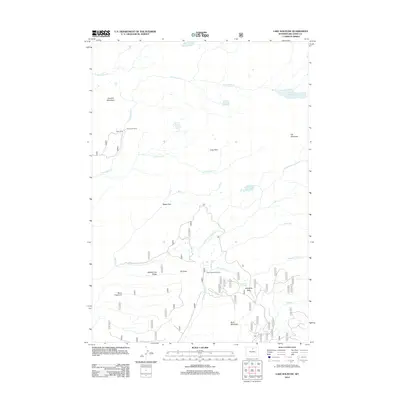
2012 Map of Lake Solitude
USGS Topo · Published 2012About this map
Lake Solitude and the surrounding high-country terrain of the Big Horn range dominate this landscape, which is defined by a network of seasonal camps and alpine meadows. The high-altitude activity in this portion of Wyoming is evidenced by the presence of Crain Camp, Hyatt Cow Camp, and Buck Creek Cow Camp, indicating the area's continued use for livestock and recreation. The drainages of Paint Rock Cr and its tributaries, including N Paint Rock Cr and Middle Paint Rock Cr, carve through the complex topography of Cement Mountain and Elk Mountain. Extensive open areas such as Long Park, Battle Park, and the descriptively named Bellyache Flats sit between prominent ridges like Middle Fork Ridge and Ed Point. This 2012 survey captures the wilderness character of the region, where only light infrastructure like Route 24 provides access to these remote peaks and lakes.
Find a feature on this map
26 named features on this map. Tap any name to fly to it.
Don’t see what you’re looking for? This feature index may not catch every label — zoom into the map to look around manually.
Map Details
Editions of this 2012 Lake Solitude Map
This is the sole edition of this map. No revisions or reprints were ever made.
Other maps of this area

1899 · Cloud peak
USGS Topo · 1:125,000

1901 · Cloud Peak
USGS Topo · 1:125,000

1955 · Sheridan
USGS Topo · 1:250,000

1958 · Sheridan
USGS Topo · 1:250,000

1960 · Shell Lake
USGS Topo · 1:24,000

1960 · Lake Solitude
USGS Topo · 1:24,000

1960 · Spanish Point
USGS Topo · 1:24,000

1962 · Sheridan
USGS Topo · 1:250,000

1967 · Brokenback Narrows
USGS Topo · 1:24,000
1967 · Meadowlark Lake
USGS Topo · 1:24,000