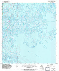
1994 Map of Lake Tambour
USGS Topo · Published 1995About this map
The coastal wetlands of Terrebonne Parish are defined by an intricate network of waterways and industrial infrastructure in the mid-1990s. The landscape is dominated by the Lapeirouse Oil and Gas Field, where numerous numbered well sites and platforms are interspersed throughout the marsh. This area, located south of the main Houma region, shows the heavy integration of energy extraction within the estuarine environment. Significant bodies of water like Lake Tambour and Lake Barre provide context for the shifting shoreline, while Bayou Terrebonne and Bayou Petit Caillou serve as primary north-south corridors. Smaller features such as Madison Bay and Grand Bayou Bourbeux illustrate the fragmented nature of the marshlands. Further south, the Seabreeze Pass Gas Field marks the transition toward more open waters, highlighting the vital role of the Bush Canal in navigating these tidal reaches.
Find a feature on this map
24 named features on this map. Tap any name to fly to it.
Don’t see what you’re looking for? This feature index may not catch every label — zoom into the map to look around manually.
Map Details
Editions of this 1994 Lake Tambour Map
This is the sole edition of this map. No revisions or reprints were ever made.
Other maps of this area

1894 · Timbalier
USGS Topo · 1:62,500

1894 · Lake Felicity
USGS Topo · 1:62,500

1894 · Dulac
USGS Topo · 1:62,500

1935 · Cocodrie
USGS Topo · 1:31,680

1935 · Bourbeux
USGS Topo · 1:31,680

1935 · Viguerie Canal
USGS Topo · 1:31,680

1935 · Montegut
USGS Topo · 1:31,680

1935 · Lake Quitman
USGS Topo · 1:31,680

1935 · Lake Gero
USGS Topo · 1:31,680

1939 · Lake Felicity
USGS Topo · 1:62,500