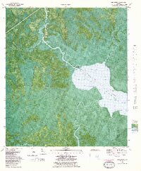
1982 Map of Lake Wimico
USGS Topo · Published 1983About this map
Lake Wimico and the surrounding coastal marshlands dominate this 1980s orthophotomap of the Florida Panhandle. The landscape is defined by the engineered passage of the Intracoastal Waterway, which cuts directly through the lake's eastern reach. While much of the area is designated as swamp, the intricate network of natural tidewaters like Possum Branch, Indian Bayou, and Horseshoe Creek reveals the original hydrological character before modern maritime navigation improvements.
Find a feature on this map
17 named features on this map. Tap any name to fly to it.
Don’t see what you’re looking for? This feature index may not catch every label — zoom into the map to look around manually.
Map Details
Editions of this 1982 Lake Wimico Map
This is the sole edition of this map. No revisions or reprints were ever made.
Other maps of this area

1943 · Port St. Joe
USGS Topo · 1:31,680

1943 · Cape San Blas
USGS Topo · 1:31,680

1943 · West Pass
USGS Topo · 1:31,680

1943 · Overstreet
USGS Topo · 1:31,680

1943 · Indian Pass
USGS Topo · 1:24,000

1943 · Jackson River
USGS Topo · 1:24,000

1944 · White City
USGS Topo · 1:24,000

1944 · Forbes Island
USGS Topo · 1:24,000

1945 · Forbes Island
USGS Topo · 1:31,680

1945 · Lake Wimico
USGS Topo · 1:31,680