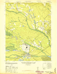
1947 Map of Lakehurst
USGS Topo · Published 1947About this map
The US Naval Air Station dominates the central landscape of this 1947 study, situated just north of the borough of Lakehurst. This military installation is bordered by extensive pine barrens and a complex network of waterways, including the Main Branch Toms River and the Ridgeway Branch. The presence of the Central Railroad of New Jersey cutting through the terrain underscores the area's importance as a transportation and defense hub during the mid-century era.
Find a feature on this map
34 named features on this map. Tap any name to fly to it.
Don’t see what you’re looking for? This feature index may not catch every label — zoom into the map to look around manually.
Map Details
Editions of this 1947 Lakehurst Map
2 editions found
Other maps of this area

1884 · Whitings
USGS Topo · 1:62,500

1888 · Barnegat
USGS Topo · 1:62,500

1888 · Asbury Park
USGS Topo · 1:62,500

1888 · Cassville
USGS Topo · 1:62,500

1888 · Whitings
USGS Topo · 1:62,500

1893 · Asbury Park
USGS Topo · 1:62,500

1893 · Barnegat
USGS Topo · 1:62,500

1894 · Cassville
USGS Topo · 1:62,500

1898 · Barnegat
USGS Topo · 1:62,500

1900 · Cassville
USGS Topo · 1:62,500
Featured Places
- Toms River, NJ
- Lakewood Township, NJ
- Jackson Township, NJ
- Manchester Township, NJ
- Pine Lake Park, Manchester Township