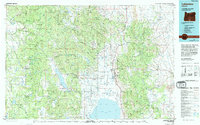
1975 Map of Lakeview
USGS Topo · Published 1994About this map
Fremont National Forest dominates this mid-1970s landscape, where the high desert of South Central Oregon meets the northern edge of the Great Basin. The town of Lakeview sits as a central hub near the north shore of Goose Lake, surrounded by small settlements and resource-based outposts like West Side and Five Corners. The map documents a geography defined by its extractive and agricultural history, featuring the White King Mine and Lucky Lass Mine in the hills to the west. Water management is critical in this arid environment, evidenced by the large Drews Reservoir and the Cottonwood Reservoir. From the heights of the Gearhart Mountain Wilderness to the sprawling flats of Brouse Prairie, the map reveals a complex network of forest service roads and gaging stations used for land management.
Find a feature on this map
142 named features on this map. Tap any name to fly to it.
Don’t see what you’re looking for? This feature index may not catch every label — zoom into the map to look around manually.
Map Details
Editions of this 1975 Lakeview Map
This is the sole edition of this map. No revisions or reprints were ever made.
Other maps of this area

1886 · Alturas
USGS Topo · 1:250,000

1886 · Modoc Lava Bed
USGS Topo · 1:250,000

1889 · Klamath
USGS Topo · 1:250,000

1889 · Long Valley
USGS Topo · 1:250,000

1892 · Modoc Lava-Bed
USGS Topo · 1:250,000

1892 · Alturas
USGS Topo · 1:250,000

1894 · Klamath
USGS Topo · 1:250,000
1951 · Clear Lake Reservoir
USGS Topo · 1:62,500

1954 · Vya
USGS Topo · 1:250,000

1954 · Alturas
USGS Topo · 1:250,000