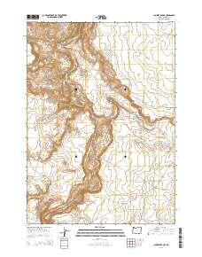
2014 Map of Lambert Rocks
USGS Topo · Published 2014About this map
Owyhee Canyon dominates this portion of Malheur County, where the Owyhee River carves through high desert terrain. The landscape is defined by its water management systems, including the Morcom Reservoir Number Two, Anawalt Reservoir, and White Wash Reservoir, which support ranching operations in this arid region. Prominent geological formations such as Lambert Rocks, Chalk Basin, and the Bogus Rim overlook the river valley, while seasonal drainages like Ryegrass Cr and Bogus Cr feed into the main canyon. This modern survey reflects the continued importance of remote infrastructure, shown through the network of access routes like Bogus Ranch Rd and Blister Rd that connect isolated landmarks such as Sand Spring.
Find a feature on this map
24 named features on this map. Tap any name to fly to it.
Don’t see what you’re looking for? This feature index may not catch every label — zoom into the map to look around manually.
Map Details
Editions of this 2014 Lambert Rocks Map
This is the sole edition of this map. No revisions or reprints were ever made.
Other maps of this area

1955 · Jordan Valley
USGS Topo · 1:250,000

1955 · Boise
USGS Topo · 1:250,000

1957 · Jordan Valley
USGS Topo · 1:250,000

1958 · Boise
USGS Topo · 1:250,000

1958 · Jordan Valley
USGS Topo · 1:250,000

1962 · Boise
USGS Topo · 1:250,000
1972 · Wrangle Butte
USGS Topo · 1:24,000

1972 · Owyhee Butte
USGS Topo · 1:24,000
1972 · Lambert Rocks
USGS Topo · 1:24,000
1972 · Sacramento Butte
USGS Topo · 1:24,000