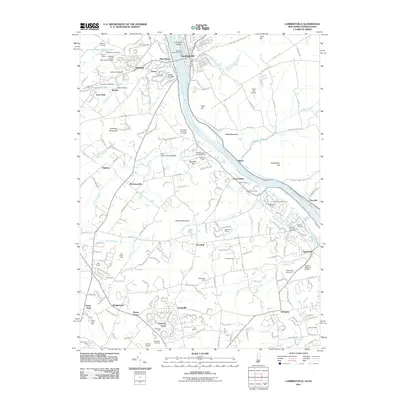
2011 Map of Lambertville
USGS Topo · Published 2011About this map
Lambertville and New Hope face one another across the Delaware River in this 2011 survey, a landscape defined by the parallel courses of the river and the Delaware and Raritan Canal. The topography is shaped by a series of prominent rises including Goat Hill, Belle Mountain, and Jericho Mountain, while the valley floor is dotted with established residential developments like Village II and Yorkshire Meadows. Local landmarks such as Bowmans Tower and the Washington Crossing Dam highlight the area's civic and memorial character. Further inland, the map captures a transition toward agricultural and estate-style properties, evidenced by named locations like Brightwood Farms and Buckland Valley Farms. Genealogists and local historians can trace legacy sites such as the Thompson Memorial Cemetery and the Solebury Cemetery, alongside smaller crossroads communities like Buckmanville, Stoopville, and Taylorsville.
Find a feature on this map
238 named features on this map. Tap any name to fly to it.
Don’t see what you’re looking for? This feature index may not catch every label — zoom into the map to look around manually.
Map Details
Editions of this 2011 Lambertville Map
This is the sole edition of this map. No revisions or reprints were ever made.
Other maps of this area

1890 · Lambertville
USGS Topo · 1:62,500

1890 · Doylestown
USGS Topo · 1:62,500

1890 · Burlington
USGS Topo · 1:62,500

1891 · Lambertville
USGS Topo · 1:62,500

1891 · Doylestown
USGS Topo · 1:62,500

1893 · Germantown
USGS Topo · 1:62,500

1893 · Burlington
USGS Topo · 1:62,500

1894 · Lambertville
USGS Topo · 1:62,500

1894 · Germantown
USGS Topo · 1:62,500

1896 · Germantown
USGS Topo · 1:62,500
Featured Places
- Lower Makefield Township, PA
- Buckingham Township, PA
- Hopewell Township, NJ
- Solebury Township, PA
- Upper Makefield Township, PA