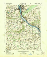
1943 Map of Lambertville
USGS Topo · Published 1943About this map
Industrial life along the Delaware River defines this mid-century landscape, where the twin towns of Lambertville and New Hope serve as central hubs for commerce and transport. The river corridor is heavily engineered with the Pennsylvania Canal on the western bank and the Delaware and Raritan Canal to the east, illustrating a mature navigation system supporting local manufacture at the Universal Bag Co and Union Paper Mills. Beyond the riverbanks, the terrain rises sharply toward Solebury Mountain and Jericho Mountain. This survey documents a transition from the industrial riverfront to the rural uplands of Upper Makkefield and Solebury townships. Notable local landmarks include St Martins Church, the Thompson Memorial Cemetery, and the historic transit point at Washington Crossing. The presence of several small schools like Fairfield School and Buckmanville School provides a clear view of the area's distributed rural population.
Find a feature on this map
58 named features on this map. Tap any name to fly to it.
Don’t see what you’re looking for? This feature index may not catch every label — zoom into the map to look around manually.
Map Details
Editions of this 1943 Lambertville Map
This is the sole edition of this map. No revisions or reprints were ever made.
Other maps of this area

1890 · Lambertville
USGS Topo · 1:62,500

1890 · Doylestown
USGS Topo · 1:62,500

1890 · Burlington
USGS Topo · 1:62,500

1891 · Lambertville
USGS Topo · 1:62,500

1891 · Doylestown
USGS Topo · 1:62,500

1893 · Germantown
USGS Topo · 1:62,500

1893 · Burlington
USGS Topo · 1:62,500

1894 · Lambertville
USGS Topo · 1:62,500

1894 · Germantown
USGS Topo · 1:62,500

1896 · Germantown
USGS Topo · 1:62,500
Featured Places
- Lower Makefield Township, PA
- Buckingham Township, PA
- Hopewell Township, NJ
- Solebury Township, PA
- Upper Makefield Township, PA