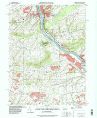
1995 Map of Lambertville
USGS Topo · Published 1998About this map
The Delaware River serves as the central artery for this region during the mid-1990s, physically separating the riverfront communities of Lambertville and New Hope. On the New Jersey bank, the Delaware and Raritan Canal State Canal parallels the river, passing the Mercer County Workhouse and entering the grounds of Washington Crossing State Park. The Pennsylvania side is characterized by the prominent ridges of Solebury Mountain and Jericho Mountain, where smaller hamlets like Solebury, Buckmanville, and Wrightstown are situated among the creek valleys.
Find a feature on this map
65 named features on this map. Tap any name to fly to it.
Don’t see what you’re looking for? This feature index may not catch every label — zoom into the map to look around manually.
Map Details
Editions of this 1995 Lambertville Map
This is the sole edition of this map. No revisions or reprints were ever made.
Other maps of this area

1890 · Lambertville
USGS Topo · 1:62,500

1890 · Doylestown
USGS Topo · 1:62,500

1890 · Burlington
USGS Topo · 1:62,500

1891 · Lambertville
USGS Topo · 1:62,500

1891 · Doylestown
USGS Topo · 1:62,500

1893 · Germantown
USGS Topo · 1:62,500

1893 · Burlington
USGS Topo · 1:62,500

1894 · Lambertville
USGS Topo · 1:62,500

1894 · Germantown
USGS Topo · 1:62,500

1896 · Germantown
USGS Topo · 1:62,500
Featured Places
- Lower Makefield Township, PA
- Buckingham Township, PA
- Hopewell Township, NJ
- Solebury Township, PA
- Upper Makefield Township, PA