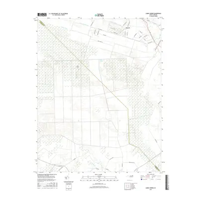
2016 Map of Lambs Corner
USGS Topo · Published 2016About this map
The Great Dismal Swamp dominates the northwestern landscape of this Currituck County region, where the intricate network of drainage canals reveals a long history of engineering the coastal wetlands. Waterways like the Guinea Mill Run Canal, Lateral A Canal, and Roland Cr Canal define the parceling of the land, cutting straight lines through the dense swamp and agricultural fields. The settlement of Moyock serves as a northern anchor, characterized by a suburban residential pattern with themed road names such as Mustang Trl and Lariat Trl, suggesting modern development encroaching upon the historic wilderness. Toward the center, the Nc61 Airport provides a small aviation footprint amidst the vast vegetation. To the south, the terrain transitions into the namesake Black Swamp and the headwaters of Sawyers Cr, illustrating the persistent and vital role of the swamp's hydrology in shaping the geography of North Carolina's northeastern corner.
Find a feature on this map
45 named features on this map. Tap any name to fly to it.
Don’t see what you’re looking for? This feature index may not catch every label — zoom into the map to look around manually.
Map Details
Editions of this 2016 Lambs Corner Map
This is the sole edition of this map. No revisions or reprints were ever made.
Other maps of this area

1939 · Moyock
USGS Topo · 1:62,500

1940 · Lake Drummond
USGS Topo · 1:62,500

1940 · South Mills
USGS Topo · 1:62,500

1945 · Lake Drummond
USGS Topo · 1:62,500

1946 · Moyock
USGS Topo · 1:62,500

1948 · Elizabeth City
USGS Topo · 1:62,500

1952 · South Mills
USGS Topo · 1:62,500

1953 · Norfolk
USGS Topo · 1:250,000
1954 · Creeds
USGS Topo · 1:24,000
1954 · Lake Drummond SE
USGS Topo · 1:24,000