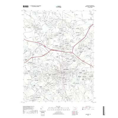
2019 Map of Lancaster
USGS Topo · Published 2019About this map
The city of Lancaster and its surrounding suburban and collegiate landscapes appear here in high detail, centered on the intersection of Pennsylvania's historic rail and road networks. The map identifies major academic and civic institutions, including Franklin and Marshall College and the Thaddeus Stevens College of Technology, alongside the Lancaster County Courthouse. This 2019 survey documents a densely layered cultural geography, where modern residential developments like Beverly Estates and Eden Heights sit adjacent to numerous historic burial grounds such as the Shaurai Shomayim Cem and Mellinger Mennonite Cem. The Conestoga River and its many tributaries, like Little Conestoga Cr and Stauffer Run, frame the city's growth. To the north, the Lancaster Airport and the Norfolk Southern railway lines underscore the region's importance as a transportation hub within the Pennsylvania Dutch Country.
Find a feature on this map
123 named features on this map. Tap any name to fly to it.
Don’t see what you’re looking for? This feature index may not catch every label — zoom into the map to look around manually.
Map Details
Editions of this 2019 Lancaster Map
This is the sole edition of this map. No revisions or reprints were ever made.
Other maps of this area

1902 · Lancaster
USGS Topo · 1:62,500

1904 · Lancaster
USGS Topo · 1:62,500

1906 · New Holland
USGS Topo · 1:62,500

1908 · New Holland
USGS Topo · 1:62,500

1912 · Quarryville
USGS Topo · 1:62,500

1912 · Mc Calls Ferry
USGS Topo · 1:62,500

1941 · New Holland
USGS Topo · 1:62,500

1943 · Lancaster
USGS Topo · 1:62,500

1943 · Quarryville
USGS Topo · 1:62,500

1943 · Mc Calls Ferry
USGS Topo · 1:62,500
Featured Places
- Lancaster, PA
- West Lampeter Township, PA
- Willow Street, West Lampeter Township
- Millersville, PA
- East Petersburg, PA