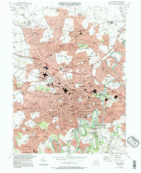
1995 Map of Lancaster
USGS Topo · Published 1996About this map
The Conestoga River winds through this mid-1990s landscape, bordering the dense urban grid of Lancaster and its sprawling suburban reaches. The map highlights the city's role as an educational and industrial hub, featuring the campus of Franklin and Marshall College and the Stevens State Sch of Tech. North of the city center, the Stockyards and the Lancaster Airport reflect the region's commercial infrastructure, while the Conrail lines facilitate regional transport through neighborhoods like Dillerville and Rossmere.
Find a feature on this map
149 named features on this map. Tap any name to fly to it.
Don’t see what you’re looking for? This feature index may not catch every label — zoom into the map to look around manually.
Map Details
Editions of this 1995 Lancaster Map
This is the sole edition of this map. No revisions or reprints were ever made.
Other maps of this area

1902 · Lancaster
USGS Topo · 1:62,500

1904 · Lancaster
USGS Topo · 1:62,500

1906 · New Holland
USGS Topo · 1:62,500

1908 · New Holland
USGS Topo · 1:62,500

1912 · Quarryville
USGS Topo · 1:62,500

1912 · Mc Calls Ferry
USGS Topo · 1:62,500

1941 · New Holland
USGS Topo · 1:62,500

1943 · Lancaster
USGS Topo · 1:62,500

1943 · Quarryville
USGS Topo · 1:62,500

1943 · Mc Calls Ferry
USGS Topo · 1:62,500
Featured Places
- Lancaster, PA
- West Lampeter Township, PA
- Willow Street, West Lampeter Township
- Millersville, PA
- East Petersburg, PA