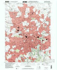
1997 Map of Lancaster
USGS Topo · Published 2000About this map
Franklin and Marshall College and the Theological Seminary anchor the western edge of the city, reflecting the institutional core of this late-1990s landscape. The urban expanse of Lancaster is shown in detail, including its historic civic center around the Courthouse and the specialized medical facilities at General Hospital and St Joseph Hospital. The map captures the significant northward suburban progression through Neffsville and toward the Lancaster Airport, as well as industrial and commercial corridors like those housing the Park City Shopping Center.
Find a feature on this map
136 named features on this map. Tap any name to fly to it.
Don’t see what you’re looking for? This feature index may not catch every label — zoom into the map to look around manually.
Map Details
Editions of this 1997 Lancaster Map
This is the sole edition of this map. No revisions or reprints were ever made.
Other maps of this area

1902 · Lancaster
USGS Topo · 1:62,500

1904 · Lancaster
USGS Topo · 1:62,500

1906 · New Holland
USGS Topo · 1:62,500

1908 · New Holland
USGS Topo · 1:62,500

1912 · Quarryville
USGS Topo · 1:62,500

1912 · Mc Calls Ferry
USGS Topo · 1:62,500

1941 · New Holland
USGS Topo · 1:62,500

1943 · Lancaster
USGS Topo · 1:62,500

1943 · Quarryville
USGS Topo · 1:62,500

1943 · Mc Calls Ferry
USGS Topo · 1:62,500
Featured Places
- Lancaster, PA
- West Lampeter Township, PA
- Willow Street, West Lampeter Township
- Millersville, PA
- East Petersburg, PA