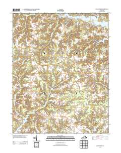
2013 Map of Lancaster
USGS Topo · Published 2013About this map
Lancaster and its surrounding rural communities are captured here within Virginia’s Northern Neck, where the landscape is defined by the winding reaches of the Great Wicomico River and the Western Br Corrotoman River. The settlement pattern follows a network of historic crossroads, including Chestnut Grove, Browns Store, and Wicomico Church, reflecting the area’s longstanding agricultural and maritime heritage. The geography is punctuated by significant water features such as Davis Millpond and Camps Millpond, while the shoreline along Indian Point and Cedar Point highlights the intricate finger-like tributaries typical of this coastal region. Land use remains largely rural, with the Miskimon Lookout Tower standing as a sentinel over the wooded swamps like McMahon Swamp and Callahan Swamp. This survey provides a clear view of the intersection of historic landings like Sampsons Wharf and modern thoroughfares such as the Jessie Dupont Memorial Hwy.
Find a feature on this map
49 named features on this map. Tap any name to fly to it.
Don’t see what you’re looking for? This feature index may not catch every label — zoom into the map to look around manually.
Map Details
Editions of this 2013 Lancaster Map
This is the sole edition of this map. No revisions or reprints were ever made.
Other maps of this area

1916 · Kilmarnock
USGS Topo · 1:48,000

1917 · Heathsville
USGS Topo · 1:48,000

1917 · Urbanna
USGS Topo · 1:62,500

1917 · Morattico
USGS Topo · 1:62,500

1917 · Kilmarnock
USGS Topo · 1:62,500

1918 · Morattico
USGS Topo · 1:62,500

1926 · Morattico
USGS Topo · 1:62,500

1942 · Kilmarnock
USGS Topo · 1:62,500

1943 · Richmond
USGS Topo · 1:250,000
1944 · Sunnybank
USGS Topo · 1:31,680