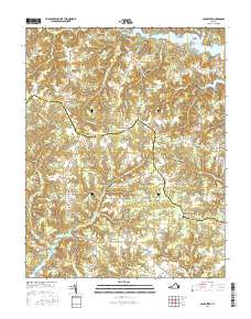
2016 Map of Lancaster
USGS Topo · Published 2016About this map
The historical seat at Lancaster anchor this Virginia Northern Neck landscape, where the colonial-era boundaries between Lancaster and Northumberland counties meet. The map reveals a high-density network of traditional crossroads settlements and family-named corners, including Browns Corner, Hardins Corner, and McNeals Corner, which point to a long history of agricultural centers and local commerce. The terrain is deeply defined by the intricate hydrology of the Chesapeake Bay watershed, where tidal fingers like the Western Branch Corrotoman River and the Great Wicomico River create a series of points and necks, such as Broad Neck and Indian Point. Evidence of early industry and community life persists through features like Davis Millpond and the Willie Chapel Cem, while smaller hamlets like Miskimon and Wicomico Church suggest the enduring social geography of this coastal region.
Find a feature on this map
83 named features on this map. Tap any name to fly to it.
Don’t see what you’re looking for? This feature index may not catch every label — zoom into the map to look around manually.
Map Details
Editions of this 2016 Lancaster Map
This is the sole edition of this map. No revisions or reprints were ever made.
Other maps of this area

1916 · Kilmarnock
USGS Topo · 1:48,000

1917 · Heathsville
USGS Topo · 1:48,000

1917 · Urbanna
USGS Topo · 1:62,500

1917 · Morattico
USGS Topo · 1:62,500

1917 · Kilmarnock
USGS Topo · 1:62,500

1918 · Morattico
USGS Topo · 1:62,500

1926 · Morattico
USGS Topo · 1:62,500

1942 · Kilmarnock
USGS Topo · 1:62,500

1943 · Richmond
USGS Topo · 1:250,000
1944 · Sunnybank
USGS Topo · 1:31,680