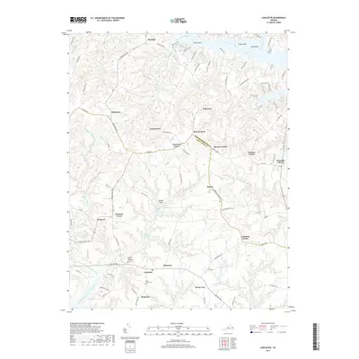
2019 Map of Lancaster
USGS Topo · Published 2019About this map
The Lancaster County Courthouse serves as the focal point for this Tidewater landscape, where the town of Lancaster sits at the junction of several historical crossroads. The map reveals a pattern of rural settlements and named corners, such as McNeals Corner and Lankford Corner, which define the social geography of the Virginia Northern Neck. A network of wetlands and tidal waters, including the Western Branch Corrotoman River and McMahon Swamp, dissects the terrain, illustrating the coastal hydrology that has long influenced development in the region. The map captures several small communities like Wicomico Church and Newtown connected by a winding road system. Notable landmarks such as Davis Millpond and the Willie Chapel Cem provide specific points of interest for those researching local family history or the evolution of these colonial-era parishes.
Find a feature on this map
89 named features on this map. Tap any name to fly to it.
Don’t see what you’re looking for? This feature index may not catch every label — zoom into the map to look around manually.
Map Details
Editions of this 2019 Lancaster Map
This is the sole edition of this map. No revisions or reprints were ever made.
Other maps of this area

1916 · Kilmarnock
USGS Topo · 1:48,000

1917 · Heathsville
USGS Topo · 1:48,000

1917 · Urbanna
USGS Topo · 1:62,500

1917 · Morattico
USGS Topo · 1:62,500

1917 · Kilmarnock
USGS Topo · 1:62,500

1918 · Morattico
USGS Topo · 1:62,500

1926 · Morattico
USGS Topo · 1:62,500

1942 · Kilmarnock
USGS Topo · 1:62,500

1943 · Richmond
USGS Topo · 1:250,000
1944 · Sunnybank
USGS Topo · 1:31,680