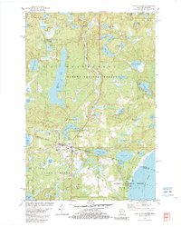
1982 Map of Land O'Lakes
USGS Topo · Published 1982About this map
The northern borderland where Wisconsin and Michigan meet is defined here by a dense concentration of glacial lakes and the deep timber of the Ottawa National Forest and Nicolet National Forest. The settlement of Land O' Lakes serves as the focal point, situated at the junction of the Chicago and North Western railroad and the interstate boundary line. This 1982 survey reveals a landscape transitioned into a prominent recreational and transportation hub, featuring the Land O' Lakes Airport and various lakefront developments like Reimers Island on Duck Lake. Local heritage and community life are anchored by landmarks such as St John Ch, Hope Ch, and the Land O' Lakes Cemetery, while the presence of a Gravel Pit and Wilson Springs indicates the local industrial and natural resources utilized by residents during this era.
Find a feature on this map
70 named features on this map. Tap any name to fly to it.
Don’t see what you’re looking for? This feature index may not catch every label — zoom into the map to look around manually.
Map Details
Editions of this 1982 Land O'Lakes Map
This is the sole edition of this map. No revisions or reprints were ever made.
Other maps of this area

1938 · Phelps
USGS Topo · 1:48,000

1946 · Star Lake
USGS Topo · 1:48,000

1950 · Phelps
USGS Topo · 1:48,000

1950 · Star Lake
USGS Topo · 1:48,000

1952 · Watersmeet
USGS Topo · 1:62,500

1952 · Thayer
USGS Topo · 1:62,500

1955 · Starlake
USGS Topo · 1:62,500

1956 · Phelps
USGS Topo · 1:62,500

1958 · Iron River
USGS Topo · 1:250,000

1960 · Iron River
USGS Topo · 1:250,000